
Manaslu Circuit route overview: the short answer
The Manaslu Circuit is a 155–215 km trek around Manaslu (8,163 m) in the Gorkha district of central Nepal. It starts in the Budhi Gandaki gorge at Machha Khola (930 m), climbs north through Jagat, Deng and Namrung to Samagaun (3,530 m) under the north face, carries on to Samdo and Dharamsala, crosses Larkya La pass at 5,106 m, then drops west through Bimthang into the head of the Marsyangdi at Dharapani. Walked east to west, as it always should be.
The classic guided version takes 14 days door to door from Kathmandu, of which ten are spent walking. The reason the distance is not one straight number is honest and worth saying early: the jeep road keeps creeping up the Budhi Gandaki, so where you start walking depends on which year you go. See map vs reality below. What has not changed, and is not going to soon, is that the middle of this route has no road at all.
| Total distance | ~155 km (96 miles) on our 14-day trip; ~190 km if walked from Arughat |
|---|---|
| Direction | East to west (Machha Khola → Samagaun → Larkya La → Dharapani) |
| Start of walking | Machha Khola (930 m), or wherever the jeep stops |
| Highest point | Larkya La, 5,106 m (16,752 ft) |
| Highest night | Dharamsala / Larkya Phedi, 4,460 m |
| Lowest point on foot | Machha Khola, 930 m |
| Total ascent | Roughly 6,500 m cumulative over the trek |
| Districts crossed | Dhading (by road) · Gorkha · Manang · Lamjung |
| Conservation areas | Manaslu Conservation Area, then Annapurna Conservation Area from Bimthang |
- Larkya La 5,106 m, the crux
- 10 walking days on the 14-day trip
- Two river valleys: Budhi Gandaki in, Dudh Khola out
The full Manaslu Circuit route map
The circuit is not a loop in the way people picture it. It is a horseshoe: you walk up one river valley, cross a single high pass at the top, and walk down a different river valley on the far side. Those two valleys, the Budhi Gandaki and the Dudh Khola, are separated by the Manaslu massif itself, which is why the pass is unavoidable and why the trek only works in one direction.
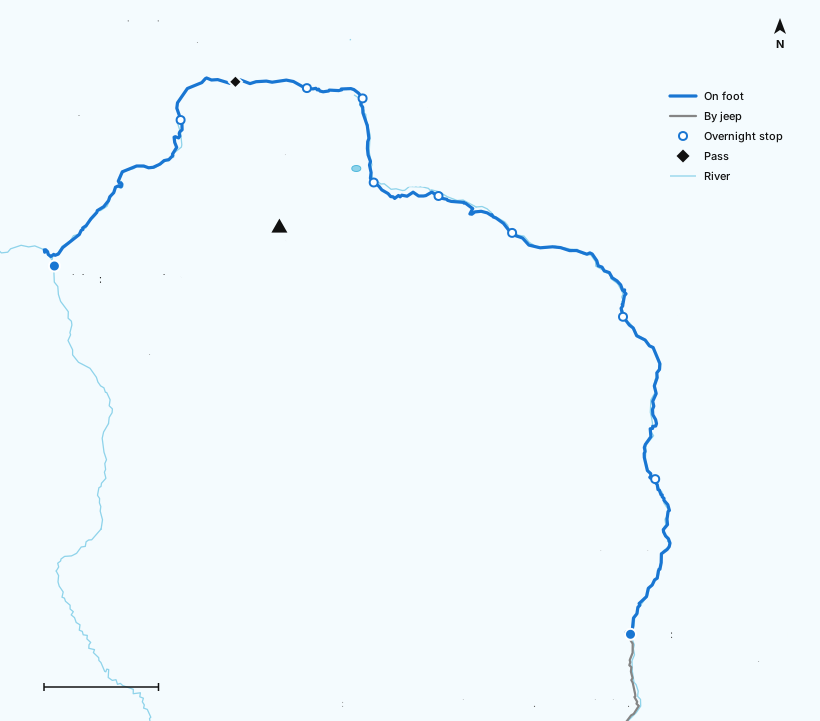
Places on this map, in walking order
- Machha Khola, 930 m
- Jagat, 1,340 m
- Deng, 1,860 m
- Namrung, 2,630 m
- Lho, 3,180 m
- Samagaun, 3,530 m
- Samdo, 3,875 m
- Dharamsala, 4,460 m
- Larkya La, 5,106 m
- Bimthang, 3,720 m
- Dharapani, 1,860 m
Also shown: the Manaslu summit (8,163 m) and Birendra Lake.
Villages on the Manaslu Circuit, with elevations
These are the overnight stops and landmarks you will actually see, north-bound up the Budhi Gandaki and then west and south down the Dudh Khola.
| Arughat | 600 m, the historic trailhead, now a stop on the drive in |
| Soti Khola | 700 m, the trailhead for most of the last decade; still used when the road above is out |
| Machha Khola | 930 m, "fish river"; where the jeep usually stops and the walking starts |
| Tatopani | 990 m, a small roadside hot spring on the gorge path |
| Jagat | 1,340 m, stone-paved village and the restricted-area checkpost: everything above here needs the permit |
| Philim | 1,570 m, a substantial Gurung village strung along terraces |
| Lokpa | ~2,040 m, the junction where the Tsum Valley trail branches off |
| Deng | 1,860 m, a handful of lodges where the valley turns north |
| Ghap | 2,380 m, carved mani stones and the start of the fir forest |
| Namrung | 2,630 m, stone gateway, second checkpost, and the point where the valley turns visibly Tibetan |
| Lihi | 2,900 m, chortens and barley terraces |
| Lho | 3,180 m, Ribung Gompa above the village and the first full view of Manaslu |
| Shyala | 3,500 m, in a bowl with Manaslu, Himal Chuli and Naike Peak around it |
| Samagaun | 3,530 m, the acclimatisation village; monastery, yak pens, seasonal health post |
| Birendra Lake | 3,450 m, glacial lake an hour above Samagaun; the gentle rest-day walk |
| Pungyen Gompa | ~3,900 m, on a shelf beneath the south-east face; the best half-day on the route |
| Manaslu Base Camp | ~4,800 m, a long day up from Samagaun and back; serious acclimatisation |
| Samdo | 3,875 m, the last permanent village, settled by Tibetan refugees in the 1960s |
| Rui La | 4,998 m, the pass into Tibet three hours above Samdo; the 16-day acclimatisation walk |
| Dharamsala (Larkya Phedi) | 4,460 m, not a village: a few huts on open ground, limited beds, no shop, no clinic |
| Larkya La | 5,106 m, the pass, the prayer flags, the whole point |
| Bimthang | 3,720 m, yak meadow ringed by Manaslu's western glaciers; the descent ends here |
| Kharche | 2,785 m, back into rhododendron and pine |
| Goa | 2,515 m, apple orchards and warm air again |
| Tilije | 2,300 m, where you rejoin something like a road |
| Dharapani | 1,860 m, on the Marsyangdi and on the Annapurna Circuit; the trek ends here |
| Besisahar | 760 m, district town, where the mountain road meets the highway to Kathmandu |
Full day-by-day timings, teahouses and meal stops are on the 14-day Manaslu Circuit itinerary.
Manaslu Circuit altitude profile
The circuit's altitude profile is a long, patient climb followed by one enormous drop. From Machha Khola you gain height steadily for nine days, sleeping higher almost every night, and then in a single day you go from 4,460 m to 5,106 m and down to 3,720 m. That day, a 646 m climb followed by a 1,386 m descent, is the longest single stage on any mainstream Nepal teahouse trek.
Distance and altitude behind this profile
| Point on the route | Km on foot from Machha Khola | Elevation (m) |
|---|---|---|
| Machha Khola | 0 | 930 |
| Jagat | 22 | 1,340 |
| Deng | 42 | 1,860 |
| Namrung | 61 | 2,630 |
| Lho | 72 | 3,180 |
| Samagaun | 81 | 3,530 |
| Samdo | 89 | 3,875 |
| Dharamsala | 96 | 4,460 |
| Larkya La | 106.8 | 5,106 |
| Bimthang | 120 | 3,720 |
| Dharapani | 145 | 1,860 |
Sleeping altitude, night by night
What matters for acclimatisation is not the height you touch during the day but the height you sleep at. This is the sleeping-altitude ladder on the classic route.
| Overnight stop | Elevation (m) | Elevation (ft) | Gain on previous night | Zone |
|---|---|---|---|---|
| Machha Khola | 930 | 3,050 | n/a | Low |
| Jagat | 1,340 | 4,395 | +410 m | Low |
| Deng | 1,860 | 6,100 | +520 m | Low |
| Namrung | 2,630 | 8,630 | +770 m | Moderate |
| Lho | 3,180 | 10,430 | +550 m | Moderate |
| Samagaun | 3,530 | 11,580 | +350 m | High |
| Samagaun (rest day) | 3,530 | 11,580 | 0 m | High |
| Samdo | 3,875 | 12,713 | +345 m | High |
| Dharamsala | 4,460 | 14,633 | +585 m | Very high |
| Larkya La (crossed, not slept) | 5,106 | 16,752 | +646 m in one morning | Very high |
| Bimthang | 3,720 | 12,205 | −740 m | High |
Two things stand out on that table, and both are why we build the trip the way we do. The Samagaun rest day is not padding. It is the only night on the route where you gain nothing, and it is the reason most trekkers cross the pass comfortably. And the Samdo to Dharamsala night is the aggressive one, a 585 m gain at an altitude where 500 m is the usual ceiling, at a place with no village and no clinic. Read why that matters in our Manaslu Circuit altitude sickness guide.
Manaslu Circuit distance: how far is it in kilometres?
The honest answer: about 155 km (96 miles) on the standard 14-day trip, roughly 177 km if you start walking at Soti Khola, and closer to 190 km if you walk all the way from Arughat as people did before the road. Anyone giving you a single confident number is quoting a particular roadhead without saying which one.
| Arughat → Dharapani, fully walked | ~190 km / 118 mi |
| Soti Khola → Dharapani, the figure most sources quote | ~177 km / 110 mi |
| Our 14-day trip (jeep to Machha Khola, out from Dharapani) | ~155 km / 96 mi on foot |
| 19-day circuit with Tsum Valley | ~215 km / 134 mi on foot |
Stage-by-stage distances
These are the individual sections. Add up whichever ones you are actually walking and you have your own number.
| Stage | Distance | Walking time | Sleep at | Usually |
|---|---|---|---|---|
| Arughat → Soti Khola | 14 km | 4–5 h | 700 m | Driven |
| Soti Khola → Machha Khola | 22 km | 6–7 h | 930 m | Driven |
| Machha Khola → Jagat | 22 km | 6–7 h | 1,340 m | Walked |
| Jagat → Philim → Deng | 20 km | 6–7 h | 1,860 m | Walked |
| Deng → Ghap → Namrung | 19 km | 6–7 h | 2,630 m | Walked |
| Namrung → Lihi → Lho | 11 km | 4–5 h | 3,180 m | Walked |
| Lho → Shyala → Samagaun | 9 km | 4 h | 3,530 m | Walked |
| Samagaun acclimatisation walk | 8–14 km | 4–7 h | 3,530 m | Walked |
| Samagaun → Samdo | 8 km | 3–4 h | 3,875 m | Walked |
| Samdo → Dharamsala | 7 km | 3–4 h | 4,460 m | Walked |
| Dharamsala → Larkya La → Bimthang | 24 km | 8–10 h | 3,720 m | Walked |
| Bimthang → Tilije → Dharapani | 25 km | 7–8 h | 1,860 m | Walked |
| Dharapani → Besisahar → Kathmandu | n/a | 9–10 h | 1,400 m | Driven |
| Lokpa → Mu Gompa → Lokpa (Tsum Valley) | ~60 km | 5 days | up to 3,700 m | Optional extension |
Averaged across the walking days on our 14-day trip that is about 16 km a day, which is a long British hill day, done ten days running, at two to four times the altitude. That combination is what makes it hard, more than any single climb does. See difficulty and fitness for what it feels like in practice.
Map of Manaslu Circuit start and end points
Where the circuit starts
Arughat (600 m) is the historical trailhead, and Soti Khola (700 m) was the standard one for most of the last decade. Both are now normally driven past. In practice there are three realistic starting points, and which one applies to you depends on the state of the road in the month you go:
- Soti Khola (700 m), the older option. Adds a day of hot, low gorge walking. Still used when the road above is washed out, which happens most monsoons.
- Machha Khola (930 m), our default and the honest answer for most departures. Jeep from Kathmandu all day, start walking the next morning in the gorge proper.
- Further north still, when the road allows. Some seasons a jeep gets past Machha Khola towards Khorlabesi or beyond. We use it if it is safe and if it does not push you too high too fast, and we tell you the plan before you fly rather than after.
Where the circuit ends
Once you are down at Bimthang the trek is effectively over: you have crossed the pass and everything beyond is downhill through forest. The ending is much simpler than on the Annapurna Circuit, because there is no flight to gamble on:
- Dharapani (1,860 m): the standard finish, a stop on the Annapurna Circuit and the first place with a road. From here it is 9 to 10 hours by jeep and bus back to Kathmandu, or rather less to Besisahar if you would prefer to break the journey.
- Out via Besisahar to Pokhara: if you are continuing your holiday rather than flying home, Pokhara is a shorter and more pleasant drive than Kathmandu. Say so when you book and we will route it that way.
- Carry on up the Annapurna Circuit: Dharapani is on it. Trekkers with three or four weeks sometimes link the two over Thorong La. It is a serious undertaking and needs its own acclimatisation plan; ask us rather than assuming.
Manaslu Circuit side-trip map: Tsum Valley, Manaslu Base Camp and Rui La
Three detours branch off the main circuit. Two of them go higher than the trail they leave, which makes them excellent acclimatisation and also means they need respect.
Tsum Valley (up to ~3,700 m at Mu Gompa)
Leaves the main trail at Lokpa and runs north-east into a hidden valley that was closed to foreigners until 2008. Two working monasteries at Mu Gompa and Rachen Gompa, a valley-wide Buddhist tradition of non-violence towards animals, and almost no trekking infrastructure. It adds five to six days and a separate restricted-area permit. It is covered properly on the 19-day circuit with Tsum Valley.
Manaslu Base Camp (~4,800 m)
The big Samagaun rest-day walk: up past Birendra Lake and the glacier snout, then a long haul to the base camp used by climbing expeditions, roughly 1,300 m of ascent, back down to sleep at 3,530 m. Textbook climb-high-sleep-low, no extra days needed if you are moving well, and the single most useful thing you can do for your pass day. Groups who want it done properly, with a spare day around it, take the 16-day base camp itinerary.
Rui La and the Tibetan border (4,998 m)
Three hours above Samdo, on an old trading route that is still walked by Samdo villagers. You cannot cross into Tibet, but you can stand on the pass and look at it, and at almost 5,000 m it is the best possible preparation for Larkya La two days later. It needs an extra night at Samdo, which is what the 16-day side-trip itinerary is for.
GPS track and GPX download
You will never be navigating alone on this route: a licensed guide is a legal condition of the restricted-area permit. But a GPX track on your phone is still worth having, for knowing how far the next teahouse is, for checking your altitude against the acclimatisation plan, and for the morning when cloud comes down on the broad upper section of Larkya La.
- Download the route: Manaslu Circuit GPX track, Arughat to Dharapani, from OpenStreetMap, with the overnight stops as waypoints. Booked trekkers also get a GPX of the exact route we walk, including the Samagaun acclimatisation options and the Tsum Valley branch.
- Offline maps: download the Nepal region in Organic Maps, Maps.me or Gaia GPS before you leave Kathmandu. OpenStreetMap coverage of the Manaslu trail is decent but thinner than on the Annapurna trails, so do not treat a missing teahouse as proof it is not there.
- Paper backup: the Himalayan MapHouse Manaslu and Tsum Valley sheet is the standard, sold in Kathmandu for a few pounds. Buy one even if you never open it.
- Battery: GPS drains a phone fast in the cold, and charging above Namrung is paid, slow and solar. Carry a 20,000 mAh power bank. See the packing list.
- No signal above Samagaun, and patchy below it. Download everything, including your insurance certificate, before you leave Kathmandu.
Map vs reality: how far the road has got
Every Manaslu itinerary you read online starts at a different village, and it is not because the operators disagree. It is because the roadhead moves, and a page written in 2018 is describing a walk that now starts a day further north.
A jeep track has been pushed up the Budhi Gandaki from Arughat over the last decade, past Soti Khola and on towards Machha Khola and beyond. It was built for the people who live there, for supplies, for medical access, for children getting to school, and objecting to it from a trekking perspective is not a good look. But it does change the trek, and it changes where day one starts.
Three things are worth knowing before you compare two itineraries:
- The road is only at the bottom. Above Jagat there is no vehicle road and there is no realistic prospect of one soon. The section that matters, Namrung to Samagaun to Samdo to the pass, is exactly as it was. This is the fundamental difference between Manaslu and the Annapurna Circuit, where roads reach Manang on one side and Muktinath on the other.
- The road is not reliable. It washes out. Most monsoons take a section of it, and it is sometimes still out in early September. A Manaslu itinerary that promises a jeep to a specific village six months ahead is promising something nobody can promise.
- Losing the bottom day is not a loss. The Arughat to Soti Khola stretch was always the least interesting walking on the route. The gorge above Machha Khola, where the trail is cut into the rock and the river is a long way down, is where it gets good.
Our position, plainly: we quote Machha Khola as the start because that is where the jeep gets to on most departures, we tell you if it is going to be Soti Khola instead, and we do not build an itinerary that only works if the road is perfect. If you want the version with the most walking, the 16-day side-trip itinerary adds the days at altitude rather than in the valley, which is where they are worth having.
Plan your circuit with this map
Working out your own version of the circuit comes down to four decisions, in this order:
- How many days do you have? Twelve gets you over the pass. Fourteen is the comfortable standard. Sixteen buys the acclimatisation margin. Nineteen adds the Tsum Valley.
- When are you going? The pass is a different proposition in November than in March, and the permit costs more in autumn. See best time to trek the Manaslu Circuit.
- Who is coming with you? Not a preference on this route: two trekkers is the legal minimum for the restricted-area permit. See permits.
- What is your budget? Our guided circuit is from £1,295 per person, all three permits and the guide included: the full breakdown is on the cost page.
